Friday, April 27, 2012

Day 57-59 - Dragoooooooon

Spent one more day at Kartchner, did a tour in the area on the moto and stopped off at the nearest town on the way back for some supplies.  Nothing too exciting.

Next day it was off to the Dragoon Mountains, just a stone throw from Tombstone.  This is where the famous Indian Chief Cochise is buried, and the county it resides in bares his name.  The drive into the base of the mountain range is about 10 miles of corduroy gravel.  Good thing I packed enough supplies for 5 days, I wasn't driving this road more than twice (out & back).

Found a nice site for my camp, and set-up the trailer.  The Dragoons aren't huge, but they are unique.
It was late afternoon by the time I had everything set-up and unloaded, so just a short moto ride was in order.  I toured a few of the surrounding gravel roads looking for opportunities for a longer ride.  I was expecting very few people here.  I was right.  But, the nearby road was a regular route for the border patrol.  About once per hour a white & green SUV would pass by from one direction or the other.  They didn't bother me, or even ever stop me to chat - a couple of times they actually pulled over so I could pass.

That night the sky on the horizon was red (...sailor's delight), but directly above was another story.  Strong winds prevailed for a couple of hours.

 View is to the west (of course), across the valley towards Kartchner. 

What I forgot to do while in Tucson was fix the generator.  Completely forgot.  Well, same problem that night, so the entertainment stopped in a few hours when my laptop battery died.  I had my morning task booked.  A pack of coyotes howled away just a short distance from the trailer.  I couldn't spot them, but they had to within about 300'.  Their chorus only lasted about a minute, then silence.

Morning.  Out comes the generator.  Spend a couple of hours taking almost completely apart.  Cleaned the carburetor (twice), cleaned out the jets, air filter, etc.  Still won't go.  Might just be spending the night with no heat.  Oh well, off for a ride.

There was a couple of mine sites in the area I wanted to visit.  Should be a good ride with some moderately technical 4x4 roads.

The first site was about 15 miles up into the Dragoons.  A windmill, well, and a few remnants from the mining days still remained.


There was also a completely open mine shaft.  You don't see these very often in BC.  Most are filled in, or gated off.

I continue up the mountain, and the road quickly turns from decent gravel to 4x4.  And it gets steeper.  And eroded.  Time for some fun.  I open up the throttle a bit and attack the hill.  Up.  Up.  Up.  Eventually I get to the top.  It's a great view West across the valley.

A short traverse on the far side of the climb and I find a group of large boulders.  No choice but to scramble up and take in the view.
The entrance was a bit of a squeeze.
All worth it though

Leftover homage to suspension

 A few more miles of descending and I come across the second mine, and terminus point of the road.
More left-over mining infrastructure

 Steeper than it looks.
Didn't hike down this slope because I wasn't sure if I could get back up.

And, another open mine shaft - this one completely vertical.  I dropped a couple of rocks down this one, and could here them bouncing off the walls for about 3.5 seconds.  That relates into about 60 meters (or almost 200 feet) deep.  Let's knock off a third due to the rocks not taking a straight path - they bounced off the walls - and we're left with about 40 meters (130 feet).  Don't want to fall down there.
On the return I noticed the first mine shaft had a twin.  It was facing the up-hill direction, so was hidden on the way in.

These were about the best finds on the ride.  I toured some other roads, but there was nothing special.  Lots of dead ends, and some decent scenery.  Starting to run low on gas, time to head back.

That night was a cold one.  Good thing I had two big blankets.  Not a huge loss though, as the riding here was not what I was expecting.  Time to move on.

Sunday, April 15, 2012

Day 55 - The Poach

Today would be interesting.  There wasn't a great deal of mountain biking south of Tucson, and very little information on the trails that did exist.  Or at least existed.  Most information was five or more years old.  When it comes to mountain biking, I've had my share of days hiking in the woods looking for a elusive trails.

My best bet was near the biggest town in the area - Sierra Vista.  The drive to the trailhead at the far side of town was about 50km.  Not close, but well worth exploring.  There are a few trails in the area, and I thought I had planned out a good loop of about 10-12 miles.  Remember all this information is old, so who knows what I'll find in 2012.

I start up the "Perimeter Trail".  It's nice and flowy singletrack, not too steep, very rideable.  Then I hit a section of small rocks that's a little challenge to negotiate.  My back tire slides off a rock and I hear a distrurbing.  Stop to check out the damage I've done to my carbon fibre XTR derailleur.

Just a flesh wound?
 Found the piece that broke off.
Only cosmetic damage.  Shouldn't (knock on wood) be a problem.  I push on.

The trail traverses a mountain side, and you gradually gain elevation.  I meet a small group of white-tail deer, and chase them into the next valley.  The views of the Sierra Vista landscape only get better.

The trail never summits, but starts descending at about the three mile mark.  The descent switchbacks a few times and is very steep & quick in places.  Not too technical though, but you wouldn't want to ride it in the opposite direction.  At the bottom the trail ends at a gravel road.  I'll need to climb this road for about 2 miles, gaining 1000 feet of elevation.

The road is steep, but well maintained, windy, and heavily treed.  Should be a pleasant climb.  After about a mile, I come across an unwelcome sign.

If my access truly was blocked, I'd have to return on the Perimeter Trail. Not something I looked forward to. The weather also looked unstable. The temperature had dropped about 5C, and rain appeared to be probable.

I reached road closure, and the signage confirmed by fears.  The road was closed to all traffic, and specifically mentioned hiking & biking.  The reason was road improvements and included blasting.  Definitely a safety issue.  But.....I was there on a weekend, and there was no sign of any other vehicles.  I debate my options for a few seconds, and decide to ignore the closure and skirt around the gates.

From here the trees open up, providing spectacular views of the adjacent cliffs.


Luckily, I don't encounter anyone else on the road before I reach my turnoff.  A trailhead sign points the way.

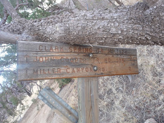
Or does it....   The sign for the connector to the "John Cooper Trail" had been taken out by a fallen tree.  No idea whether the trail was to the right or the left.  I choose left.
 
A large fire had burned this area just six months before, and the damage was total.  It burned approximately 30,000 acres, 40 homes, and 17 other buildings.  Over the course of the fire, 12,000 people were evacuated from their homes.  With all this damage, only one person suffered injury (smoke inhalation).


 In 3/4 of a mile, I reach the John Cooper Trail.  It's all downhill from here :)  The trail has a few tight switchbacks, but is mostly wide open, pedal to the metal.  In pin it down the trail and reach the bottom far too quickly.  I meet another border patrol vehicle near the parking lot, and he gives me a friendly wave.  Maybe I'm not the only one who's poaching this trail.

A light rain starts just before getting to the truck, so I don't waste much time faffing about.  As I'm packing up, I notice that the blimp I saw on the way to the Sierra Vista is still hovering.  Border patrol is serious business.

Not a long ride, but well worth the drive from Kartchner.  Coming from Tucson would be a bit far for a trail this short.

Saturday, April 14, 2012

Day 54 - High Noon

Time for some touring on the motorcycle.  The gunfighting capital of the world, Tombstone, Arizona, was under 30 miles from Kartchner.  A quick internet search gave me a list of "must see" attractions.  I selected the ones that looked most interesting, and headed out.
North most star is Kartchner

The main highway from Kartchner was straight and boring, but I soon took the left turn towards Tombstone and onto a narrower road with a few twisties.   Perfect for the moto.  Not far to Tombstone now.  But first....
Enroute is the ghost town of Fairbank.  This town was originally a small native village known as Santa Cruz.  It was "settled" in 1881 as Junction City, when the railway was built through the area.  The town received a huge boost in 1882, when the railroad station was constructed.  This would cement the town as the key supply point for the boom town of Tombstone.  Many notorious outlaws would pass through here enroute to the Territorial State Prison in Yuma.  In 1883, the post office opened and the town was renamed Fairbank.
House & stable
 Commercial building
 All-ages schoolhouse
This building was partially restored.
It now houses a small info center.
 Close-up of the house from the first picture.
This is the only residence remaining.
 Sign outside all buildings except the schoolhouse
Before the BLM took over, everything was open
 Walkway up to the train station platform
 The platform is still in great condition
You can almost see smoke on the horizon from the incoming Bisbee train

The town's prosperity, however, was short lived.  The Tombstone mine closed in 1886, and the San Pedro Valley suffered a series of droughts and a damaging flood over the next several years.  The town survived another 30 years on life support before a steady decline took hold that would not be slowed.   The town was officially abandoned in the early 1970s.

Onto Tombstone.  If you ever visit Tombstone, you'll no doubt hear the story of how it came to be.  Everyone in town appears to be reading from the same script.  There was a camp in the region that was used to launch "scouting missions" against the Apache Indians.  In 1877, a prospector named Ed Schieffelin was staying at the camp.  He would strike out on his own, sometimes for days, "looking for rocks".  The military men would say "the only stone you'll find out there is your tombstone."  Well, what Ed found was a brilliant seam of silver.  He ironically decided to call the mine Tombstone.

A town, originally named Goose Flats, was established around the mine in 1879.  It wasn't long before the town itself was renamed Tombstone.  By the mid-1880s the town population was estimated at between 15-20,000 people.  The mine operated 24/7 with many separate shifts.  This meant that miners were coming off work at all hours of the day.  To support their needs, the saloons were also open 24/7.  At the height of the town's prosperity there were 107 saloons on the main street of Tombstone.  Combine this with every person over six carrying a gun, and the consequences were obvious.

Tombstone quickly became the gunfighter capital of the world.  The streets were literally painted with blood.

In the late 1880s, the mine finally hit the water table, and flooded.  Water laboriously was pumped out for a few years to allow progress, but eventually the returns could not overcome the costs, and the mine closed in 1889.  The town almost instantly evacuated, as there was no other source of income generation.  By the 1930s, the population sunk to about 150 people.

Today about 1500 people call Tombstone Arizona home.  The town is entirely a tourist attraction, and receives the second most number of tourist visits in Arizona each year (first of course is the Grand Canyon). 


The highway passes through just a block from the main street of Tombstone.  Parking is abundant and free - didn't even have to tip anyone. The main street is cordoned off to motorised vehicles.  Shops line both sides of the street, as does a covered boardwalk to provide shade for the shoppers.  Armed gunslingers (actors) roam the streets and loiter on the corners.  They're endlessly available for photo ops - for a fee.  And tipping is encouraged.

Open only to horse traffic

The only show I wanted to see was at the Wyatt Earp Theatre (it had, by far, the best reviews).  The show was about 40 minutes long, and depicted several famous Tombstone gunfights (including the back stories).  The actors used real guns with blanks.  The same was true for all shows in Tombstone, and you could year gunfire just about any time during the day.

For $7, it was appropriately priced.  All in attendance enjoyed the show.  After the show, the hats came off - tipping was encouraged.  I didn't get any decent pictures of the show.  Still haven't got the hang of this camera for indoor shots.

Next site was the Good Enough Mine Tour, at the original Tombstone Mine.


Had about 45 minutes to kill first, so it was off for a bite to eat.  Had an exceptional fajita lunch at Cafe Margarita.  They even took $4 off because I asks for no meat :)  Gave it all back and more as a tip though.  Very worth it.

Off to the mine tour.  Our guide for the day was had been a miner all his life.  He now did mine tours and entered the occasional competition.  Here he shows us how drilling was done in the early days.
 Amazing combination of power and accuracy

The bigger jobs were done by two men.  One with a 10lb sledge hammer, the other holding a longer spike.  Surprisingly, the sledge wielder rarely missed.  Those that did, didn't have a job for very long.

Steam and air powered drills were also used, but prone to failure.
And, only air powered drills could be used underground.
 Some old equipment from the original mine
 An old safe
 Various carts for raw ores
 When you gotta go...

Once the holes are drilled, in goes the dynamite.  Drill, blast, excavate, repeat.  Some of the chambers were over two stories high.

   Most of the mine consisted of narrow tunnels about 6' wide and 7' high
 Some, even smaller
 ...and smaller

We didn't go into the above tunnel, but it was being prepped for future use.  The current owners were planning an 'aventure' tour of the entire mine system that remained above the flooded areas.  Some sections will only be accessible by crawling, and squeezing through tight openings.  In case you're interested, it should be ready this summer.

The 90 minute tour I took was priced at $15.  Well worth it.

Ended the day browsing the town shops.  Every place seemed to have more or less the same fare - trinkets, t-shirts, leather goods.  Guns were the central theme.

On the way in/out of town is the Boothill Graveyard, where many infamous outlaws were laid to rest.  All of the original headstones have been replaced with generic markers, so it's not quite the draw it deserves to be.  Or maybe it is.

It's a quick, though windy, ride back to Kartchner.  Another great day.

Tuesday, April 3, 2012

Day 53 - Boots on the Ground

Spent the day in Kartchner Park.  They had two hiking trails, and I knocked them both off in the same day.  They weren't especially taxing, so not setting any records here, but the desert heat does take a toll.

The park is located in an long flat valley with low-lying mountains on either side.  You can see for miles.

Here's a few shots of the landscape


Also had to take more pictures of cactus.

Thought the flowers on this one were rare.  Then I noticed them everywhere.  Maybe just the right time of year.

Finished the day with some work on the motorcycle.  Still had to wire-up top box I picked up in Washington.  All went smoothly.  I now had a much brighter brake light.  Not sure why I didn't take a good picture of it.  Here's the only one I have from that time frame.  I should have a better one later.

Signal lights are a little hidden from the top,
but easily seen from behind.

Tomorrow would be a light touring day.  Everything was now ready.