My best bet was near the biggest town in the area - Sierra Vista. The drive to the trailhead at the far side of town was about 50km. Not close, but well worth exploring. There are a few trails in the area, and I thought I had planned out a good loop of about 10-12 miles. Remember all this information is old, so who knows what I'll find in 2012.
I start up the "Perimeter Trail". It's nice and flowy singletrack, not too steep, very rideable. Then I hit a section of small rocks that's a little challenge to negotiate. My back tire slides off a rock and I hear a distrurbing. Stop to check out the damage I've done to my carbon fibre XTR derailleur.
Just a flesh wound?
Found the piece that broke off.
Only cosmetic damage. Shouldn't (knock on wood) be a problem. I push on.The trail traverses a mountain side, and you gradually gain elevation. I meet a small group of white-tail deer, and chase them into the next valley. The views of the Sierra Vista landscape only get better.
The trail never summits, but starts descending at about the three mile mark. The descent switchbacks a few times and is very steep & quick in places. Not too technical though, but you wouldn't want to ride it in the opposite direction. At the bottom the trail ends at a gravel road. I'll need to climb this road for about 2 miles, gaining 1000 feet of elevation.
The road is steep, but well maintained, windy, and heavily treed. Should be a pleasant climb. After about a mile, I come across an unwelcome sign.
If my access truly was blocked, I'd have to return on the Perimeter Trail. Not something I looked forward to. The weather also looked unstable. The temperature had dropped about 5C, and rain appeared to be probable.
I reached road closure, and the signage confirmed by fears. The road was closed to all traffic, and specifically mentioned hiking & biking. The reason was road improvements and included blasting. Definitely a safety issue. But.....I was there on a weekend, and there was no sign of any other vehicles. I debate my options for a few seconds, and decide to ignore the closure and skirt around the gates.
From here the trees open up, providing spectacular views of the adjacent cliffs.
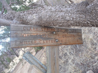
Luckily, I don't encounter anyone else on the road before I reach my turnoff. A trailhead sign points the way.
Or does it.... The sign for the connector to the "John Cooper Trail" had been taken out by a fallen tree. No idea whether the trail was to the right or the left. I choose left.
A large fire had burned this area just six months before, and the damage was total. It burned approximately 30,000 acres, 40 homes, and 17 other buildings. Over the course of the fire, 12,000 people were evacuated from their homes. With all this damage, only one person suffered injury (smoke inhalation).
In 3/4 of a mile, I reach the John Cooper Trail. It's all downhill from here :) The trail has a few tight switchbacks, but is mostly wide open, pedal to the metal. In pin it down the trail and reach the bottom far too quickly. I meet another border patrol vehicle near the parking lot, and he gives me a friendly wave. Maybe I'm not the only one who's poaching this trail.
A light rain starts just before getting to the truck, so I don't waste much time faffing about. As I'm packing up, I notice that the blimp I saw on the way to the Sierra Vista is still hovering. Border patrol is serious business.
Not a long ride, but well worth the drive from Kartchner. Coming from Tucson would be a bit far for a trail this short.


No comments:
Post a Comment