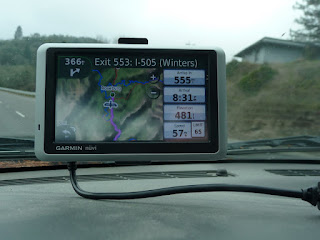
Just past Roseburg. This is where you start to climb. Note the elevation.
Towing the trailer, I wasn't looking forward to Grant`s Pass - the first of several. I drove this route back back in March this year on a trip to Vegas/Sedona/Phoenix with Matt & Chris, and remembered it to be the worst of them. Turned out I was very wrong.
Grant's Pass wasn't bad at all. I was able to maintain the speed limit (55 for trucks or ANY vehicle towing, 65 for the rest) for most of the pass. The toughest one turned out to be Siskiyou Summit. This one was steep and long. Most of the climb was spent doing 40mph. Two transport trucks stalked me the entire way up.
Topping out. Hard to read the sign, but it says:
Siskiyou Mtn. Summit
Elev. 4310 Ft.
Highest Elev.on I-5
Not out of the woods yet though. Next came Mount Shasta and my memory was starting to come back. I recall the Shasta Lake area to be the most treacherous section of road. Very windy and steep - both up and down.
Approaching Mt. Shasta
Passing Mt. Shasta.
The remainder of the evening turned out to be uneventful. Not much traffic on the road, save for the few miles in the town of Shasta Lake. The road was dry and clear. Even though it was just about freezing outside, the inside of the truck was nice and cozy. Couldn't have asked for better conditions.
Was felling good, but a nature break was required. Stopped for a quick WiFi break as well (I now had my own WiFi, so I just stopped at a rest area), then figured I throw down another 90 minutes on the road. It was 7pm, but I wanted to drive on. When I was nearing ready to stop, I found two rest areas on the GPS. One was 5 miles away, the other was 30. Hmm, another half hour in the truck, or I can have a beer and dinner in 15 minutes. I took the first one.
Ended the day at 8:20pm, and about 415 miles down the I-5 just North of Sacramento. Not bad at all. Tomorrow would be a nice cruz.


Also hard to read but this is in METERS so yeah try harder
ReplyDeletehttp://dl.dropbox.com/u/3223282/DSC_0182.jpg