Day 18 and 19 were spent re-supplying the trailer and organising my next couple of days. No phone reception at Malibu Creek set me back in the planning department. Unfortunately, the next site didn't have reception either, but full coverage was just a few miles down the road.
I was now at Casper's Regional Park near San Juan Capistrano (just South of LA) for three nights. As was the norm, very few people were here. Got a site for $26/night including power. Water wasn't not too far away, but not at the sites. Best deal of the trip so far though. One of the best things about government sites is the tax is included. None of this "only $26", then you get a bill for $30 once the taxes are settled.
On day 19 I found out there were a couple of excellent bike rides in the area (thanks Sven & D). Should have noted that info much sooner in the trip, but hey, that's part of the adventure - last minute planning. The San Juan Trail, in the Cleveland National Forest, is a point to point mountain bike/hiking trail. It's listed as 11 miles, and usually done as a loooooong shuttle. I'm not too interested in shuttles this trip, so it had to be done as an out & back.
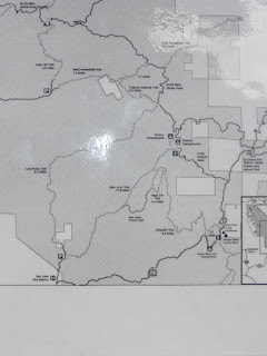
The above picture was taken AFTER the ride, and I didn't have a map with me. Looked simple enough and well signed to start. Who needs a map!
The trail finishes (starts & finishes for me) with a steep climb through about a zillion switchbacks. This was the steepest part of the trail that was still rideable. It was a relentless, yet pleasant climb.
There were mile markers along the way, and a signed post at about the half-way point. Odd place for a marker. There were no other trails leading away from this point.
Didn't stop to take many pictures, so this is the best one of the trail material. It was mostly a mixture of hard packed fine grained rock and sand. Traction was for the most part excellent, and the trail was VERY fast.
At about the 2/3 mark, I came across a trail intersection. No signs. Great. Straight was a steep, loose climb that looked like more of a DH fall-line. Left and right were well traveled bike trails. A hundred feet or so on the left (hidden in the trees) was a mile marker. I took a chance and went this way. It skirted the hill that the straight-on trail went up, and converged with that trail at the top. No idea where the right trail went. Hope I was going the right way.
Just a few hundred yards later came a fork in the road. I needed a spoon, so I passed - baddda boom. Decided on the left (high) line and continued. At least the trail was going up. If I went the wrong way, I could always easily descend and get back on track. At least it ascended for about 10 minutes....
The trail started dropping, and I started second guessing myself. Continued on though despite the warning signs. I just knew this was the way. Sure enough, within a few minutes I was at the Bluejay Campground - the 'starting' point of the San Juan Trail :) Looking back at the map, the first intersection must have been for the "San Juan Truck Trail". Glad I didn't take that trail, or I'd have been route finding for some time with all the possible turn-offs.
The ascent took 2:15 and rose 789 meters. But, not over 11 miles. According to my GPS, it was only 15km - or just over 9 miles. Did I miss some of the trail? No idea. Had a quick lunch on a vacant picnic table, then saddled-up for the descent. As you can see from the downhill profile below, there was a climb of about a kilometer not too far in. This was a difficult climb, as it was steep and rocky. Had to hike-a-bike a few sections. Then it was game on.
The total descent took 57 minutes - 22 to reach the high point, and 35 for the last 7km of pure downhill. Only one stop in the last 35 minutes, for a rider climbing up the trail. It was the only person I saw all day. Maybe because it was a weekday? For a classic trail like this and perfect weather, I was a bit surprised there wasn't far more traffic. The descent was fast and not very technical. There were only two rocky sections on the entire trail. Neither would be a challenge for a decent rider. Maybe on a short travel bike with the seat jacked. My KS dropper post and RM Altitude ate it up.
Arrived at the truck at 3:00. The only other trail I wanted to ride in the area was far too long to start at this time, so it was back to the trailer for an early beer.
Highly recommend this trail if you're in the area. It's great climb too, so nix the shuttle.


glad you finally got on a real bike ride!
ReplyDelete